
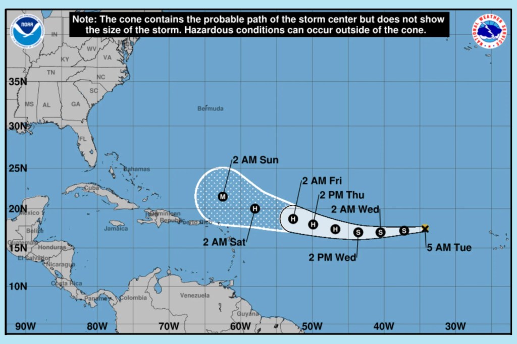
Tropical Storm Erin is expected to intensify into a hurricane within the next few days, the National Hurricane Center reported Tuesday.
As of 11 a.m., Erin was about 820 miles west of the Cabo Verde Islands, moving west at 23 mph. Forecasters expect the storm’s rapid westward track to continue for several days before slowing and shifting toward the west-northwest.
Gradual strengthening is anticipated, with Erin likely reaching hurricane status in the next couple of days and potentially becoming a major hurricane by this weekend. Maximum sustained winds are currently near 45 mph.
While it’s too early to pinpoint impacts, forecasters said the risk has grown for Erin to move closer to the northern Leeward Islands, Virgin Islands, and Puerto Rico over the weekend. Residents in those areas are urged to monitor the storm’s progress. No coastal watches or warnings are in effect at this time.
Northeastern Gulf
A surface trough is producing disorganized showers and thunderstorms in the north-central Gulf of Mexico. Development is not expected as the system moves inland later today. Heavy rainfall may cause flash flooding across parts of the Florida Panhandle, southern Alabama, southern Mississippi, and southeastern Louisiana through the next day or so.
Northwestern Atlantic
A non-tropical low several hundred miles southeast of Nova Scotia is generating showers and thunderstorms west of its center. Forecasters say some tropical or subtropical development is possible in the next day or so while the system moves near the warm Gulf Stream waters. By midweek, cooler waters should end further development chances. Formation odds remain at 10 percent for both the next 48 hours and seven days.
Follow the St. Pete-Clearwater Sun on Facebook, Instagram, Threads, Google, & X
(Image credit: National Hurricane Center)
PIE-Sun.com: local St. Pete-Clearwater news


Leave a comment