
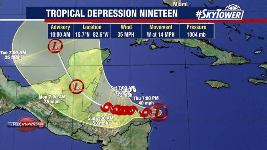
Tropical Depression 19 formed in the Caribbean Sea on Wednesday and is likely to strengthen into Tropical Storm Sara within the next 24 to 48 hours, according to forecasters.
The system is currently about 250 miles east of Isla Guanaja, Honduras, moving west at 15 mph with maximum sustained winds of 35 mph, the Weather Channel reported.
Forecasters expect the storm to move over Central America before heading into the Gulf of Mexico. However, they predict it may not regain hurricane strength before approaching Florida.
This hurricane season, which officially ends on November 30, has already seen Hurricanes Debby, Helene, and Milton cause fatalities and significant damage in parts of Florida. If Tropical Storm Sara becomes the fourth hurricane to hit Florida this season, it would break the 2004 record of three landfalls in one season, according to Accuweather.
The National Hurricane Center (NHC) indicated that the system will bring heavy rainfall, flash flooding, and mudslides to parts of Central America, including Honduras, Belize, El Salvador, eastern Guatemala, and western Nicaragua, through early next week.
AccuWeather Lead Hurricane Expert Alex DaSilva noted, “Should the storm become a hurricane, it would be the 12th of the season, highlighting the supercharged nature of this season, where the historical average is seven hurricanes.”
NHC forecasters expect the disturbance to approach near-hurricane strength as it moves near the eastern Honduras coast on Friday and Saturday. Hurricane watches and tropical storm warnings are currently in effect in the area.
The system is forecast to approach Belize and Mexico’s Yucatan Peninsula at or near hurricane strength by early next week, posing a risk of dangerous storm surge and damaging winds, according to the NHC.
AccuWeather forecasters mentioned that the system’s proximity to land early on raised concerns about its potential to strengthen. “If the center remains offshore of Nicaragua and Honduras for a couple of days, it could still reach hurricane intensity,” they said. “However, rapid strengthening to a major hurricane now seems unlikely due to the proximity to land.”
Despite this, significant rainfall is expected in the region, with up to 30 inches in parts of northern Honduras and up to 15 inches in other areas of Central America, from Belize to Nicaragua, the Weather Channel reported.
The interaction of future Tropical Storm Sara with land in Central America and the Yucatan Peninsula, which is likely to weaken the system, will influence its track and intensity.
AccuWeather forecasters explained that after moving over the region, the system may either dissipate or begin turning toward the Gulf of Mexico. “However, such a path over land for several hours would reduce its wind intensity, and it may not have time to regain hurricane strength before approaching Florida,” they noted. Additionally, water temperatures in the Gulf are not as warm as in the western Caribbean, potentially slowing any regain of wind intensity.
Greg Dee, a meteorologist for ABC Action News, agreed with this assessment. “Intensity forecasts for this system have come down significantly over the last 24 hours,” he wrote in a Facebook post. “The trend for a weaker system continues today, with models keeping it a tropical storm near Honduras. There will be a short window over the weekend for some strengthening as it moves toward Belize. The storm will then spend much of Saturday, Sunday, and Monday over the Yucatan, likely weakening to a minimal tropical storm or tropical depression during this time.”
The current forecast suggests the disturbance will enter the Gulf as a tropical storm by Tuesday, according to the Weather Channel.
Models predict the system will move east toward Florida ahead of a strong cold front from the Plains by Wednesday, experts said.
However, Dee expects the system won’t survive its time over the Yucatan. Overnight models “show either nothing or a tiny, weak, low pressure coming out over the Gulf and getting absorbed by a front with little to no additional strengthening,” he wrote. “This would be great for Florida as it basically would mean no storm. Both the presence of the front and significant upper-level wind shear would prevent anything from developing in the Gulf.”
Follow us on Facebook, Instagram, Threads, Google, & X
(Image credit: Fox 13 Tampa Bay)


Leave a comment