
A tropical disturbance, Invest 99L, is on the verge of becoming Tropical Storm or Hurricane Sara and could impact Florida’s West Coast next week, according to forecasters.
Tropical Storm Sara “could form at any time” in the Caribbean Sea, shared ABC Action News Chief Meteorologist Denis Phillips in a Wednesday morning update. Florida, already battered by Hurricanes Debby, Helene, and Milton this season, should closely monitor the disturbance, which may bring significant weather to the state’s western coast around November 20, as reported by Fox Weather.
Late-season storms, which typically form in the Caribbean as the season nears its official end on November 30, often track north toward Florida, increasing concern for a potential Florida impact.
Invest 99L currently sits over the central Caribbean, producing widespread showers and thunderstorms, with a 90% chance of developing into a tropical depression or storm within the next 48 hours, according to the National Hurricane Center (NHC). Jamaica is expected to see heavy rain through Wednesday and Thursday, and a hurricane reconnaissance aircraft is scheduled to investigate the system later on Wednesday.
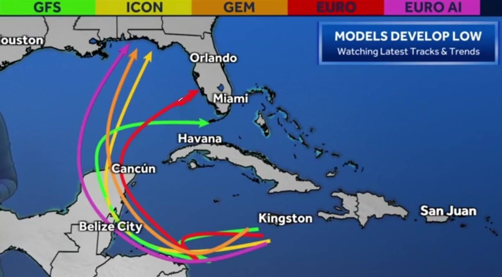
The NHC forecasts the storm to intensify as it gradually moves through the western Caribbean. By early next week, a slow turn to the northwest is anticipated, leading to a range of potential tracks and intensities. Some models suggest it could strengthen into a powerful hurricane in the Gulf of Mexico, while others predict a weaker system if it moves over Central America, Cuba, or the Yucatán Peninsula.
If the system maintains its structure and moves into the Gulf, the warmer waters in the southern part of the Gulf could lead to further strengthening before any potential approach toward Florida.
“Unfortunately, the weather setup is similar to October patterns where storms in the Caribbean often track north toward Florida,” said Fox meteorologists. A high-pressure system near the Bahamas could guide Sara north or northwest over the weekend, and a dip in the jet stream may drive it toward Florida by early next week. Many forecast models are showing a possible threat to Florida, which is raising concerns among meteorologists, although forecasts may still shift.
The ultimate path and strength of the storm at landfall remain uncertain and will depend on how much time it spends over land in Central America or the Yucatán, as well as atmospheric conditions it may encounter along the way.
“The chances of a Florida landfall are rising,” said Phillips, “but where it hits remains uncertain. A South Florida track could likely be stronger than one headed to Central or North Florida due to differences in ocean conditions and wind shear.”
Follow us on Facebook, Instagram, Threads, X
(Image credit: WESH 2 Orlando screenshot)


Leave a comment