
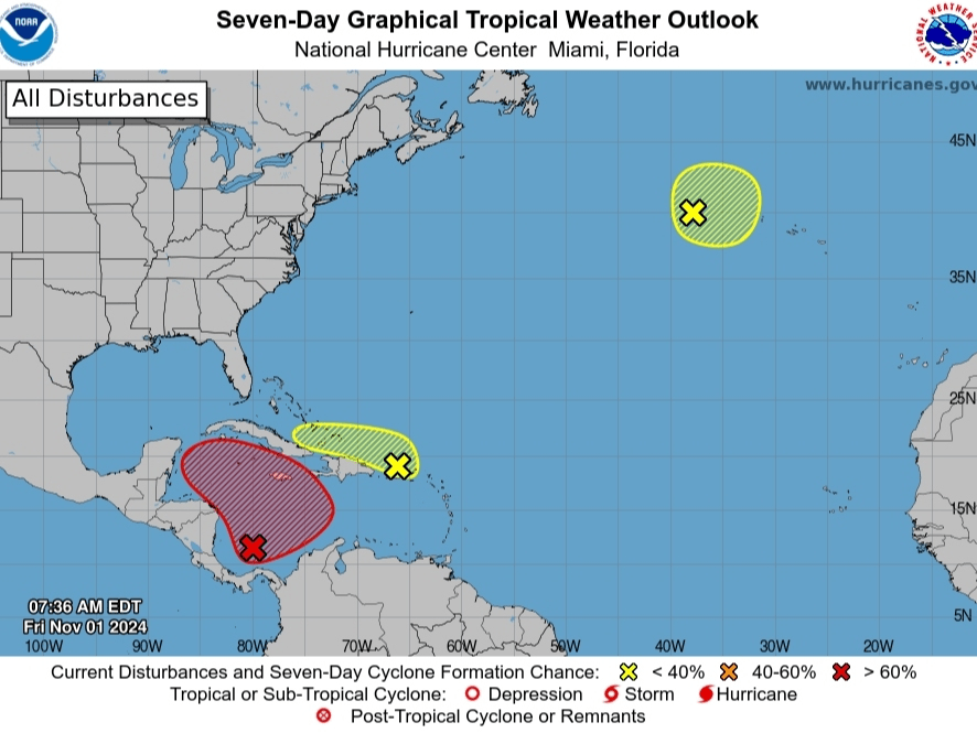
The National Hurricane Center (NHC) is currently monitoring three areas for possible tropical development, with the Caribbean system showing the highest potential for strengthening into Tropical Storm Patty.
Caribbean System Most Likely to Develop
A low-pressure system in the southwestern Caribbean presents the strongest chance of development, with forecasters giving it a 70 percent probability of forming within seven days and a 30 percent chance within two days. The system is expected to drift north or northwest over the central or western Caribbean, potentially becoming a tropical depression or storm by early next week.
FOX 13 Meteorologist Dave Osterberg notes that building high pressure over the Atlantic will likely push this system northwest toward the Gulf of Mexico. However, the system would face challenging conditions there, including cooler waters compared to six to eight weeks ago.
Secondary System Near Puerto Rico
A new trough of low-pressure weather near Puerto Rico is producing extensive showers and thunderstorms across the Greater Antilles and surrounding waters. While slow development is possible as it moves west-northwest, its primary impact will be locally heavy rainfall from the northern Leeward Islands westward to eastern Cuba and the southeastern Bahamas.
Forecaster Insights
ABC Action News Chief Meteorologist Denis Phillips downplayed concerns, noting that November tropical systems are rare and this potential storm would likely weaken significantly in the Gulf due to high wind shear and drier air. “While we probably see Patty within a week, the threat is much lower with this than previous storms,” Phillips stated.
FOX 13’s Paul Dellegatto described the situation as “complicated,” citing multiple features including the Puerto Rico trough, the Caribbean development area, and a large high-pressure ridge over Florida. He suggests Florida is unlikely to be affected, as the high-pressure system should keep any developing storm to the west.
Third System in North Atlantic
The NHC is also tracking a non-tropical low-pressure area about 400 miles west of the Azores, though it has only a 10 percent chance of subtropical development as it moves eastward over the next week.
Impact Outlook
Gulf Coast residents should stay informed but not overly concerned. Any potential impacts along the Gulf Coast wouldn’t occur until late next week or the following weekend, and would likely involve a weakened system rather than a major hurricane threat.
(Image credit: National Hurricane Center/NOAA)


Leave a comment